
3D Photogrammetry
Mid-South360 creates remarkably detailed 3D photogrammetric models (digital twins) of existing structures or landscapes. Clients utilize these models for greater visualization during projects, including for communication with stakeholders.
Enhanced Visualization and Design Accuracy
Realistic Models: 3D photogrammetry produces highly accurate and detailed models of existing landscapes, buildings, or infrastructure. Architects and engineers can use these models to better visualize the existing conditions and create designs that integrate smoothly into the environment.
Pre-Construction Visualization: Clients, stakeholders, and teams can visualize the design in its real-world context before construction begins, reducing misunderstandings and improving alignment on project vision.
Improved Client Communication and Stakeholder Buy-In
Interactive Models: 3D photogrammetry provides interactive, realistic models that can be explored from any angle. This is especially useful during presentations, as it allows clients and stakeholders to better understand the project's scope and complexity.
AR/VR Integration: These models can be easily integrated into augmented and virtual reality (AR/VR) platforms, allowing for immersive experiences where clients and stakeholders can "walk through" or "fly over" a proposed site or structure.
More Informed Decision-Making
Accurate Site Representation: Having an exact, measurable 3D model of the site or structure allows engineers and architects to analyze real-world conditions, such as terrain features, structural integrity, or environmental constraints, making it easier to identify potential challenges or adjustments.
Data-Driven Planning: Accurate topography or structural details lead to better planning and allocation of resources, reducing waste and the potential for costly on-site adjustments.
Facilitating Collaboration Across Teams
Common Data Environment: Teams from different disciplines (architecture, civil engineering, mechanical engineering) can all work from the same 3D model, ensuring alignment and reducing the risk of conflicting designs or approaches. This reduces costly rework and improves overall efficiency.
Remote Collaboration: Using cloud-based platforms to share photogrammetric models allows team members to collaborate remotely, increasing flexibility and speeding up review cycles.
Faster and More Accurate Site Surveys
Reduced Survey Time: Traditional surveying methods are time-consuming and labor-intensive. With photogrammetry, data can be captured quickly using drones or cameras, and the 3D models generated can provide precise measurements.
Documentation and Progress Monitoring: Throughout the project lifecycle, photogrammetric models can be used to document progress, compare different phases, and even identify deviations from the planned design.
Cost and Risk Reduction
Early Issue Detection: Accurate 3D models allow for the detection of potential issues early in the design phase, such as spatial conflicts or environmental impacts, which reduces the risk of expensive changes during construction.
Improved Bidding and Estimating: Contractors can use these models to more accurately estimate material quantities, project costs, and construction timelines, leading to more competitive bids and fewer surprises during the construction process.
Marketing and Business Development
Project Showcases: Photogrammetric models can be used as part of marketing materials, providing high-quality visualizations of completed or in-progress projects to potential clients.
Winning Proposals: Realistic, detailed models help companies present compelling proposals, giving them an edge in competitive bidding situations.
Incorporating 3D photogrammetry into the AEC workflow boosts efficiency, improves communication, and increases the likelihood of project success, making it a valuable tool for enhancing business in the industry.
View Model: The Sterick Building
View Model: Simmons Bank Liberty Stadium Demolition

View Model: The Puck Building, Historic Facade Inspection
View Model: Overton Square

Case Study: Historical facade inspection
-
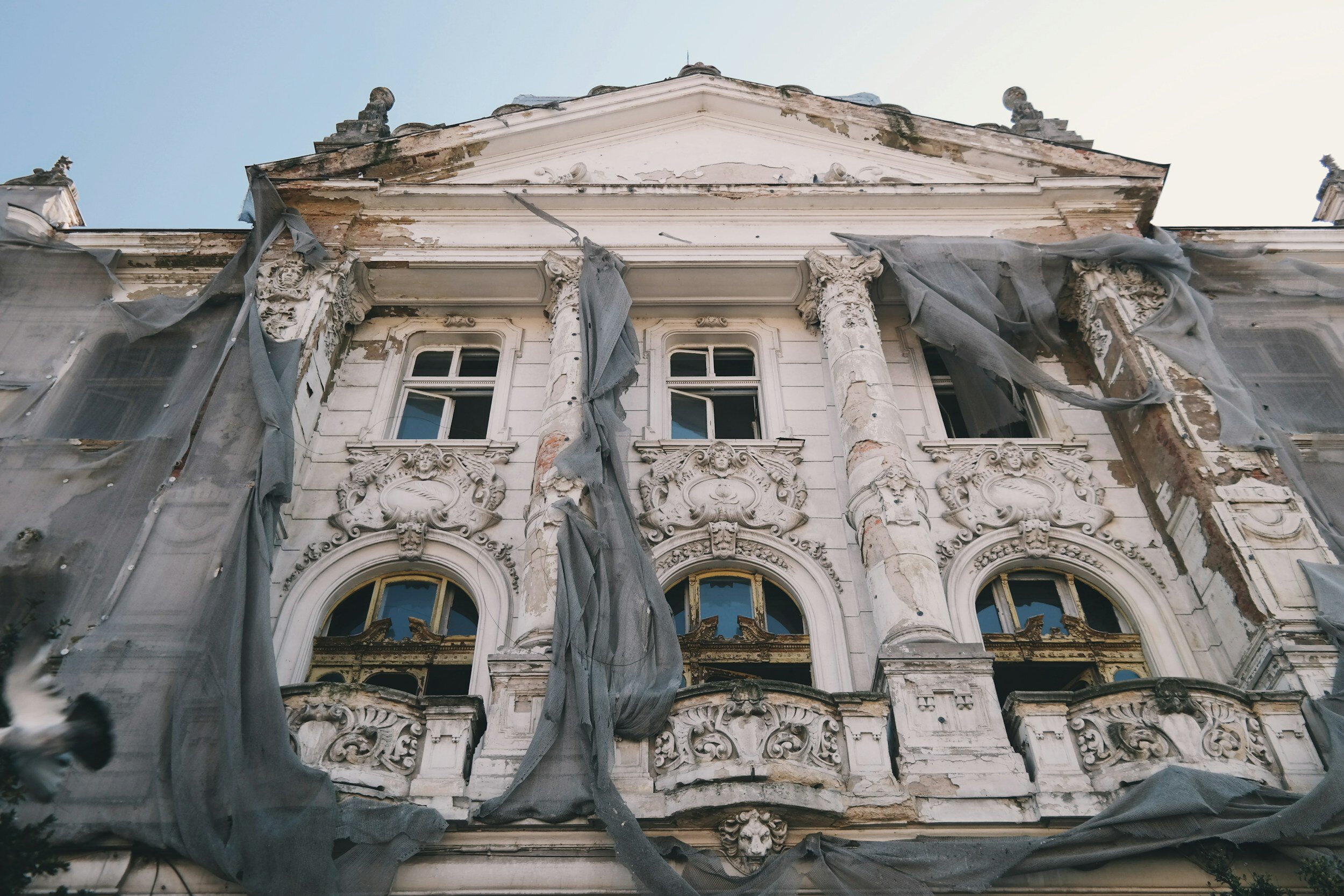
Historic Building Facade
Built in 1912, The Puck Building in downtown Memphis features an interesting facade capped by “Puck”, the sprite from Shakespeare’s A Midsummer Night’s Dream.

-
Detailed 3D Model
Employing drone and terrestrial photography, Mid-South360 created an incredibly detailed 3D photogrammetric model to document the historic building’s current condition, as well as for facade inspection purposes.

Case Study: Simmons Bank Liberty Stadium Demolition
-
Stadium Demolition
The Simmons Bank Liberty Stadium in Memphis, TN is undergoing a $220MM renovation to improve the fan experience. Phase 2 includes demolition of the west side of the stadium, including the former box seats and press area.

-
Detailed 3D Model
Mid-South360 provides construction progress visual assets in many forms, including photogrammetric models. These models allow clients to view the current state of a project in high-resolution 3D.

case study: the sterick building
-
As-Built Structure
The Sterick Building is a 29-story (365 ft.) tall neo-gothic building located in downtown Memphis, TN. The building has been vacant for many years, but is currently undergoing revitalization. The original facade features intricate stonework at a hard-to-reach elevation.

-
Detailed 3D Model
Mid-South360 captured thousands of images and then processed a 3D photogrammetric model of the top five floors and the roof. This model not only permanently preserves this historic structure in its present condition, but provides an accurate as-built model for visualization purposes.
